


Greece Bulgaria Romania Serbia Bosnia Aegean Islands 1910 Ottoman Script Map Armenian Publisher
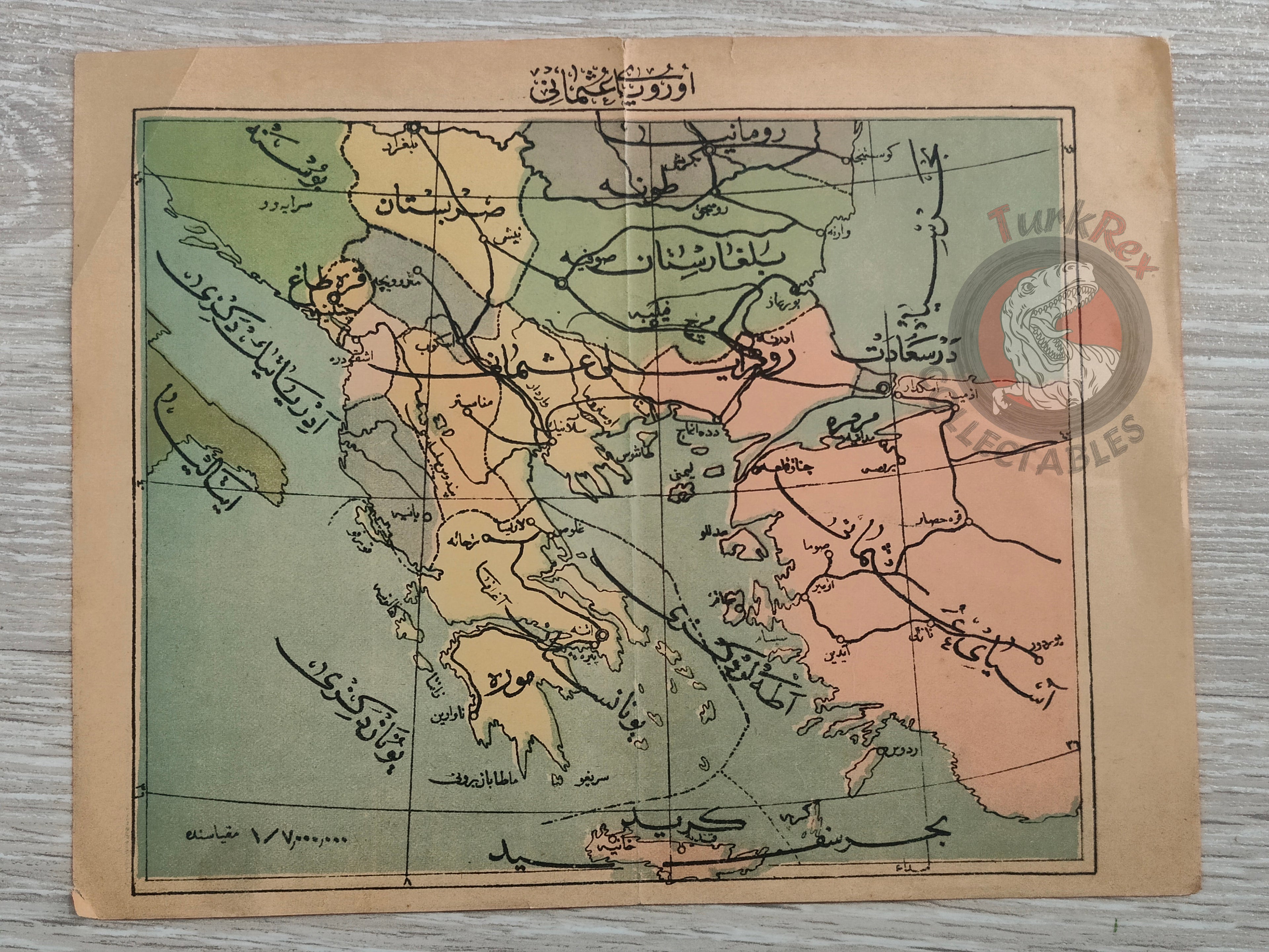
Title: Ottoman Map of Avrupa-i Osmani – From Yeni Usul Haritalı ve Resimli Rehnüma-yı Coğrafya (1910)
Description:
An original Ottoman Turkish map of “Avrupa-i Osmani”, published in 1328 AH (1910 CE) in the geography book Yeni Usul Haritalı ve Resimli Rehnüma-yı Coğrafya, authored by Behram Münir. The map was printed in Istanbul by Artin Asaduryan ve Mahdumları Şirket-i Mürettibiyesi, a well-known Armenian publishing house of the late Ottoman Empire.
The map depicts the Ottoman territories in Europe, including Greece, Bulgaria, Romania, Serbia, Bosnia, and the Aegean islands. Produced during the politically volatile years just before the Balkan Wars (1912–13), it reflects the Ottoman Empire’s perception of its European domains at the dawn of the 20th century.
The Yeni Usul Haritalı ve Resimli Rehnüma-yı Coğrafya (“New Method Illustrated and Mapped Guide to Geography”) was designed as a modern educational tool, combining maps and illustrations to teach geography in schools. Maps from this volume are scarce today, as such works were heavily used by students and few copies survived intact.
Key Features:
- Date: 1328 AH (1910 CE)
- Title: Avrupa-i Osmani
- Author: Behram Münir
- Publisher: Artin Asaduryan ve Mahdumları Şirket-i Mürettibiyesi (Armenian Ottoman publishers, Istanbul)
- Dimensions: 21.1 × 16.5 cm
- Region Depicted: Greece, Bulgaria, Romania, Serbia, Bosnia, and the Aegean Islands
- Historical Context: Produced on the eve of the Balkan Wars, showing Ottoman Europe before significant territorial losses
- Cultural Significance: Rare example of an Ottoman school geography book map, published by an Armenian printing house, highlighting both intercommunal collaboration and the modernization of education