


Migration of the Kayı Tribe Ottoman Map History Anatolia Arabian Peninsula Iran Iraq Middle East
Ottoman Turkish Map Migration of the Kayı Tribe (Osmanlıların Cedd-i Âlâsı Olan Kayı Hanların Şarktan Garba Doğru Hicretleri)
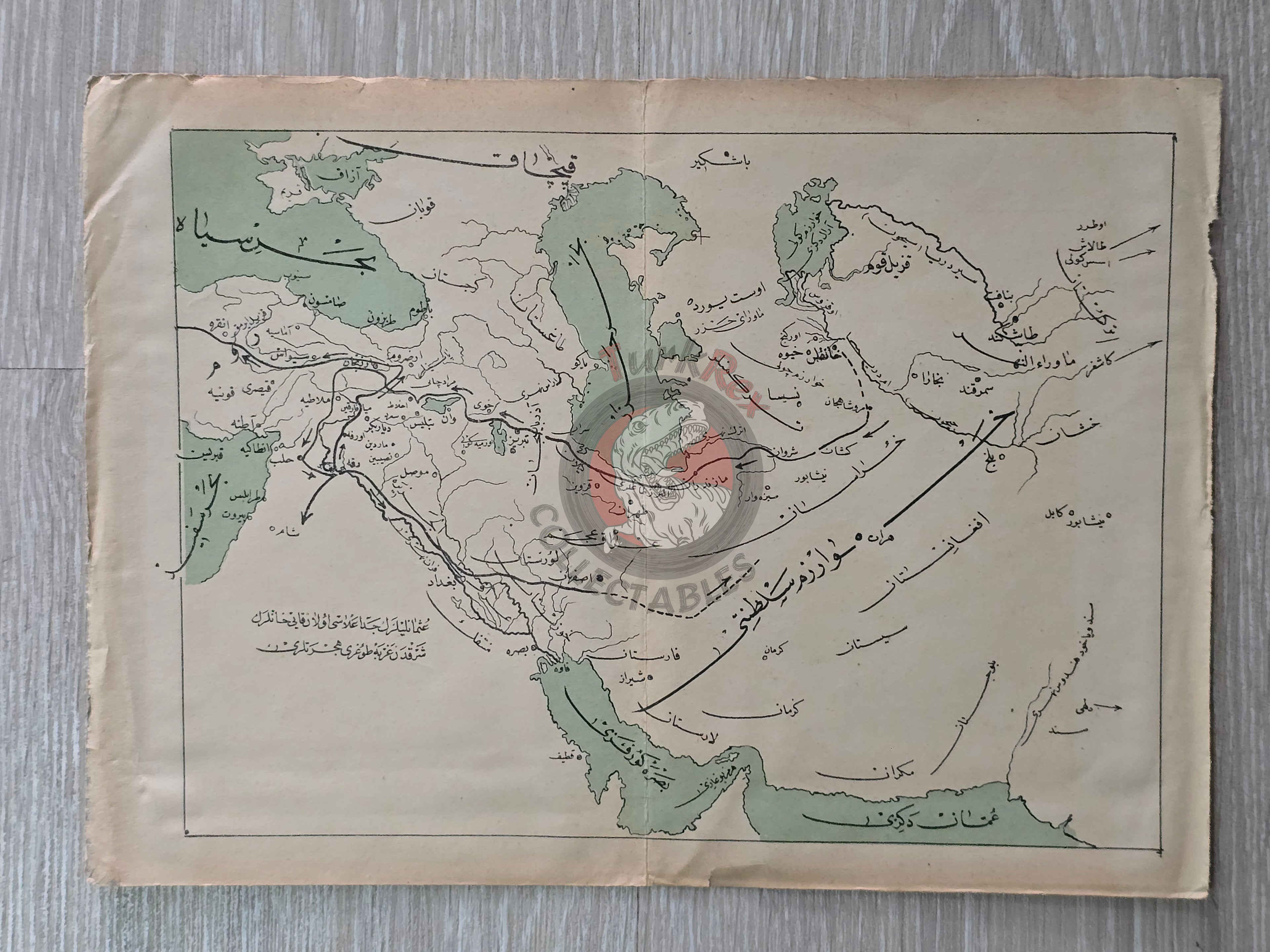
Description:
An Ottoman Turkish historical map titled “Osmanlıların Cedd-i Âlâsı Olan Kayı Hanların Şarktan Garba Doğru Hicretleri” (“The Migration of the Kayı Ancestors of the Ottomans from East to West”). Measuring 28.5 × 20.5 cm, the map illustrates the westward migration of the Kayı Tribe of the Oghuz Turks from Central Asia into Anatolia during the 13th century, a movement that laid the foundations of the Ottoman dynasty.
The map covers a wide geographic area, including Anatolia, the Arabian Peninsula, Turkmenistan, Afghanistan, Iran, Iraq, Azerbaijan, and the Caspian Sea.
The migration of the Kayı Tribe was part of the larger Turkic westward migrations triggered by the Mongol invasions. Initially, the Kayı came under the influence of the Khwarazmian (Harzemşah) State, providing temporary military support against the Mongols. Following the fall of the Khwarazmians in 1231, the Kayı moved into the lands of the Anatolian Seljuks, eventually settling in the Söğüt and Domaniç region under the leadership of Ertuğrul Gazi, where the foundations of the Ottoman Beylik were established.
Although the exact source book of this map is unknown, it was likely published in the early 20th century within an Ottoman history volume.
Key Features:
-
Title: Migration of the Kayı Tribe - Ancestors of the Ottomans
-
Date: Early 20th century Ottoman publication (exact source unknown)
-
Language: Ottoman Turkish (Arabic script)
-
Dimensions: 28.5 × 20.5 cm
-
Geographic Coverage: Central Asia to Anatolia (Anatolia, Arabian Peninsula, Turkmenistan, Afghanistan, Iran, Iraq, Azerbaijan, Caspian Sea)
-
Significance: A rare Ottoman historical map tracing the legendary migration of the Kayı, symbolizing the origin story of the Ottoman dynasty and its connection to Turkic migrations.