


Ottoman 1910 Saint Gotthard Campaign Map Archduchy of Austria Ahmed Muhtar Pasha Military
Ottoman Military Map of the Austrian Region - Saint Gotthard Campaign (1664) - From Sen Gotar’da Osmanlı Ordusu by Ahmed Muhtar Pasha (1326 AH / 1910 CE)
Description:
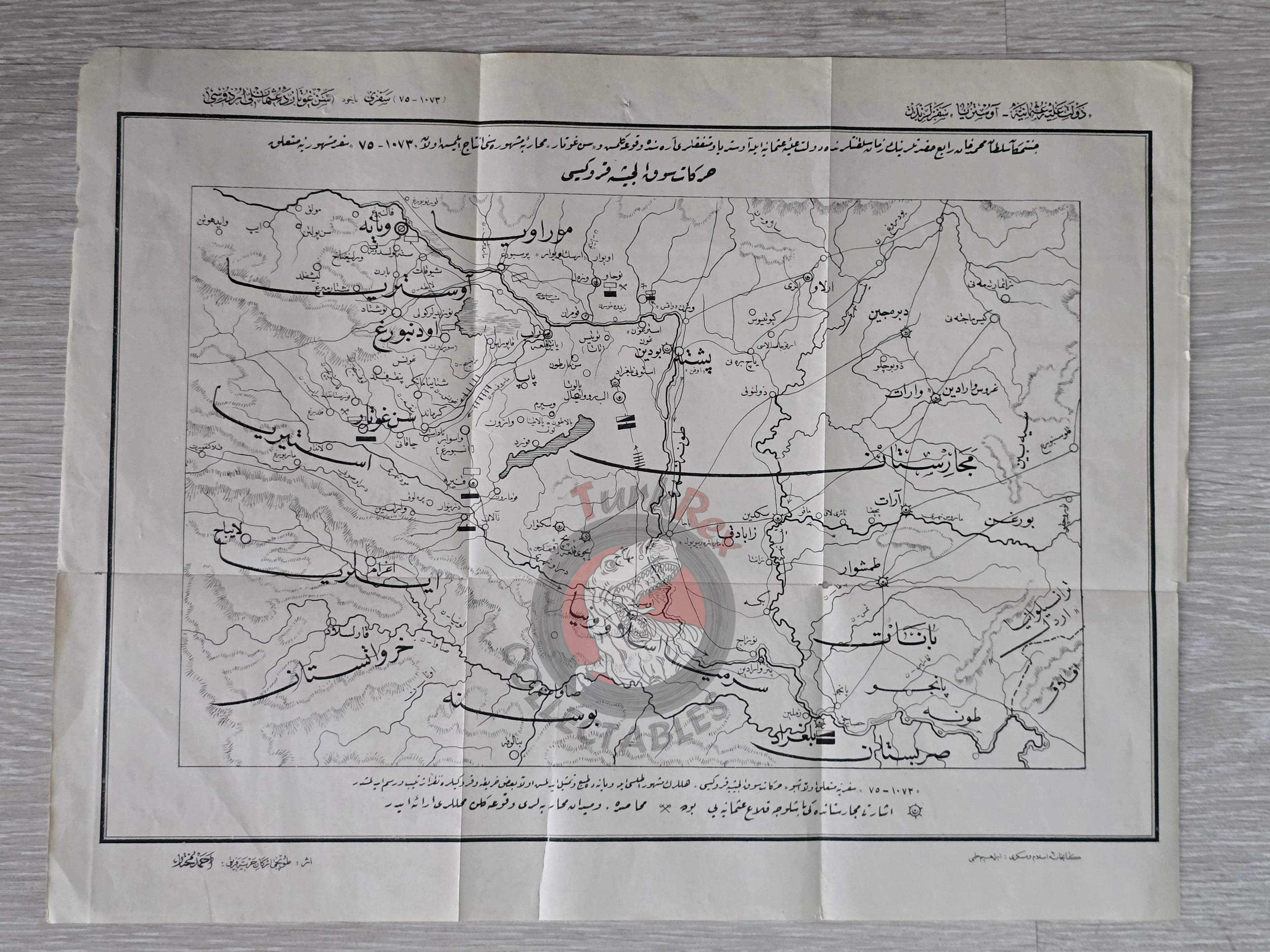
A large Ottoman Turkish military campaign map of the Austrian region, measuring 45.8 × 35.3 cm, published in 1326 AH (1910 CE) in Ahmed Muhtar Pasha’s Sen Gotar’da Osmanlı Ordusu. Printed in Istanbul at Artin Asaduryan Press (Armenian publisher), this map illustrates the Saint Gotthard Campaign, fought on 1 August 1664 between the Ottoman Empire under Sultan Mehmed IV (Cennetmekan Sultan Mehmed Han-ı Rabi Hazretleri) and the combined forces of the Austrian Archduchy, the Holy Roman Empire, and allied European states.
The map is titled: “Cennetmekan Sultan Mehmed Han-ı Rabi Hazretlerinin Zaman-ı Saltanatlarında Devlet-i Aliyye-i Osmaniyye ile Avusturya ve Müttefikleri Arasında Vukua Gelen Sefere Ait Askeri Harekat Haritası.”
This detailed lithographed campaign map was produced as part of Ahmed Muhtar Pasha’s historical-military study, intended to educate officers and military cadets on the strategic lessons of past Ottoman-European conflicts.
Key Features:
-
Region: Austrian territories (Saint Gotthard battlefield, 1664)
-
Event Depicted: Saint Gotthard Battle, 1 August 1664
-
Publication Date: 1326 AH / 1910 CE
-
Source: Sen Gotar’da Osmanlı Ordusu by Ahmed Muhtar Pasha
-
Publisher: Artin Asaduryan Press, Istanbul
-
Dimensions: 45.8 × 35.3 cm
-
Format: Large Ottoman military campaign map
-
Significance: Rare Ottoman military-historical map illustrating a decisive 17th-century battle, published by one of the empire’s most distinguished military commanders and historians