


Turkey and Neighboring States 1928 Ottoman Atlas Map Faik Sabri Middle East Eastern Anatolia
Ottoman Turkish Double-Sided Map of Turkey and Neighboring States / Eastern Anatolia - from Orta Atlas by Faik Sabri Duran (1928)
Description:
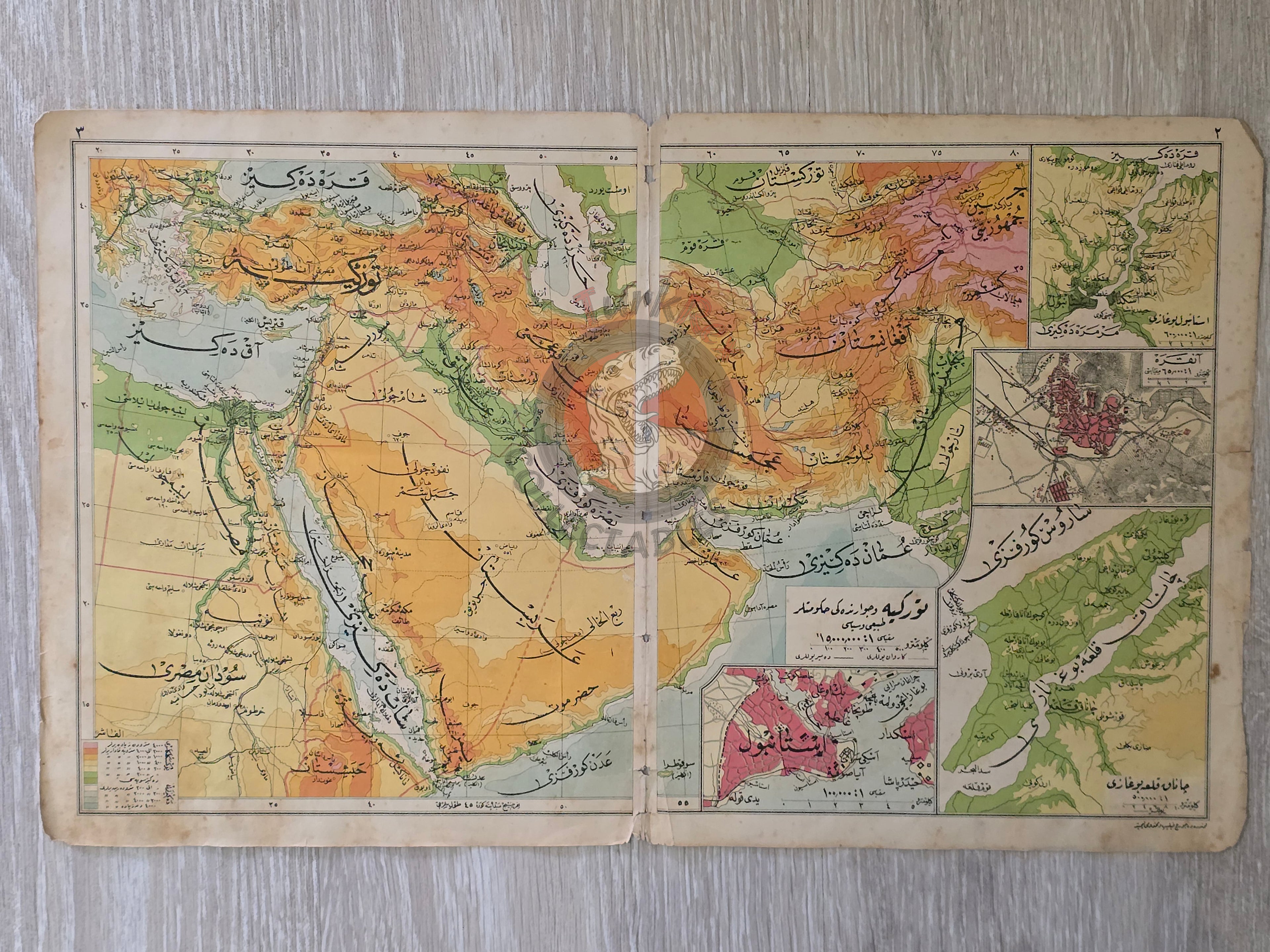
A double-sided Ottoman Turkish map, measuring 45.4 × 27.7 cm, from Faik Sabri Duran’s “Orta Atlas” (Middle Atlas), published in Istanbul, 1928 by Kanaat Kütüphanesi.
Although printed in the Republican era, the atlas was published in the Arabic-based Ottoman script, as it preceded the Alphabet Reform of November 1, 1928, when the Latin alphabet was officially adopted. This makes the atlas a historically significant example of the last generation of educational works printed in Ottoman script.
On one side, the map depicts Turkey and Neighboring States (Türkiye ve Civarı Hükümetler), showing a wide geographical and political coverage including Iran, Syria, Armenia, Saudi Arabia, Iraq, Palestine, Egypt, Greece, Bulgaria, Georgia, and surrounding regions.
On the other side, the sheet presents illustrations of geographical forms (coğrafi şekiller) alongside a detailed map of Eastern Anatolia (Şarkî Anadolu), offering both cartographic and didactic value.
The author, Faik Sabri Duran (1882–1943), was one of Turkey’s most influential geographers, educators, and authors. Educated at the Sorbonne (1908–1912), he returned to teach at the Darülfünun in Istanbul, pioneering modern geography education. Decorated with ten medals by Sultan Abdülhamid II, Duran authored numerous atlases and geography works, with the Orta Atlas standing out as a milestone in Turkish cartographic history.
Key Features:
-
Title/Subject: Turkey and Neighboring States / Eastern Anatolia & Geographical Illustrations
-
Publication Date: 1928 (pre-Alphabet Reform)
-
Atlas: Orta Atlas (Middle Atlas)
-
Author/Editor: Faik Sabri Duran (1882–1943)
-
Publisher: Kanaat Kütüphanesi, Istanbul
-
Language: Ottoman Turkish (Arabic script)
-
Dimensions: 45.4 × 27.7 cm
-
Coverage:
-
Turkey and Neighboring States (Iran, Syria, Armenia, Saudi Arabia, Iraq, Palestine, Egypt, Greece, Bulgaria, Georgia, etc.)
-
Eastern Anatolia Map
-
Illustrations of geographical formations
-
-
Significance: A rare double-sided Ottoman-script atlas map, issued on the eve of the Alphabet Reform, combining both regional political geography and physical geography education.